1.
6 Best Power Line Drones
1.1.
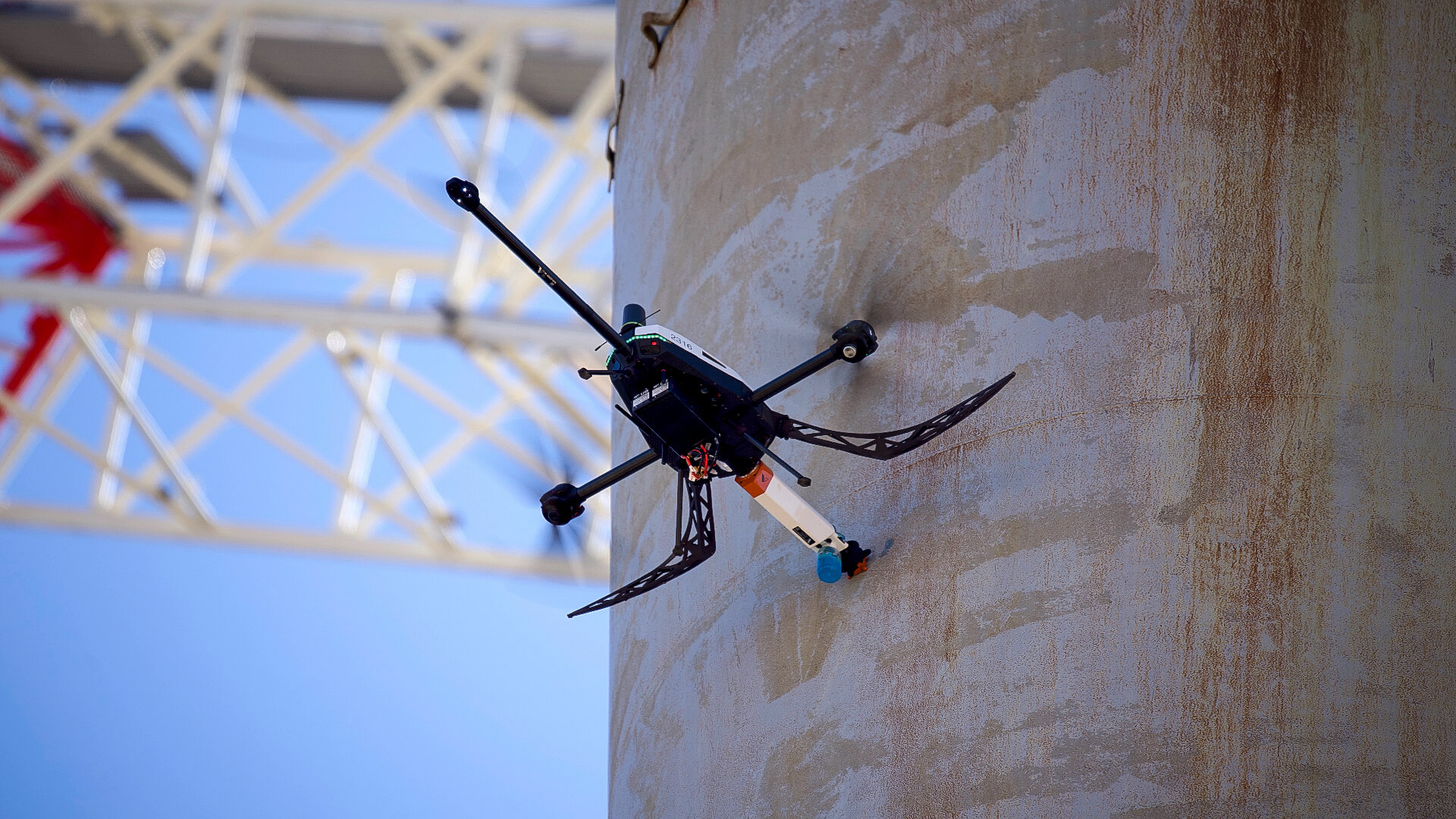
Voliro T
1.2.
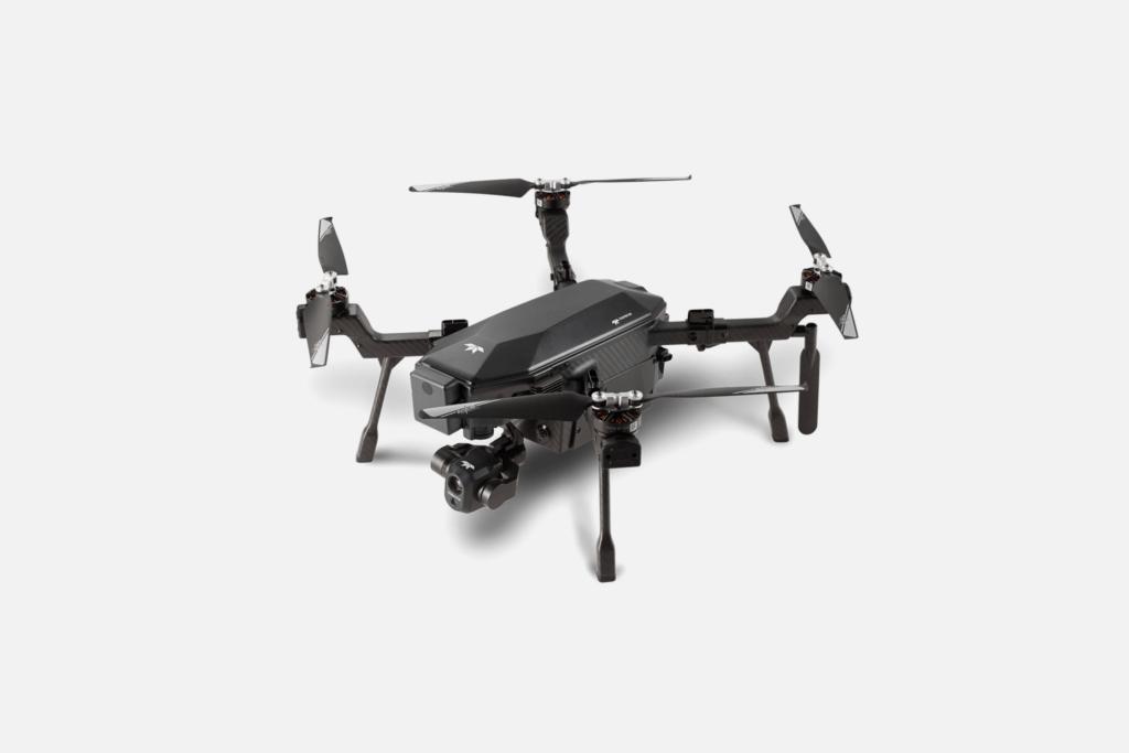
Ranger Pro
1.3.
DJI Matrice 350 RTK
1.4.
SIRAS
1.5.
DJI Mavic 3 Thermal
1.6.
IF1200
2.
Drone Power Line Inspection Drives Efficiencies
1.
6 Best Power Line Drones
1.1.
Voliro T
1.2.
Ranger Pro
1.3.
DJI Matrice 350 RTK
1.4.
SIRAS
1.5.
DJI Mavic 3 Thermal
1.6.
IF1200
2.
Drone Power Line Inspection Drives Efficiencies
Over a century, electricity networks expanded from a 17-mile transmission line between Willamette Falls and Portland, in the US to more than 79M km/48M miles of power lines globally. Electrical grids keep our homes lit, our businesses – running, and our cities – visible even to the ISS astronauts.
However, this infrastructure needs regular inspections and maintenance to avoid power outages, transmission failures, and wildfires. Helicopter-driven inspections, let alone manual ones, are time-consuming and unsafe. According to T&D World, 50 utility line workers die on the job each year, while others endure electrical burns and injuries.
Inspection drones eliminate such risks and make pole climbing unnecessary. Maneuverable and fitted with advanced payloads, the power line inspection drones streamline data collection, improve data quality, and reduce operational hazards for workers.
You’ve got plenty of power line drone inspection models. Fixed-wing enterprise models can cover large distances on a single battery charge, often fully autonomously. Purpose-built inspection drones, equipped with advanced image sensing systems, can detect surface-level cracks or perform non-destructive testing at heights.
If you’re starting a power line drone inspection program, prioritize models with smart obstacle detection and high resistance to harsh conditions (high-voltage environment, strong winds, high operating temperatures). Look for models with a good selection of payloads for richer data collection. The best models can capture structural defect data, and take coating thickness measurements, and temperature readings for electrical faults.
In the list below, you’ll find power line inspection drones that tick all these boxes.
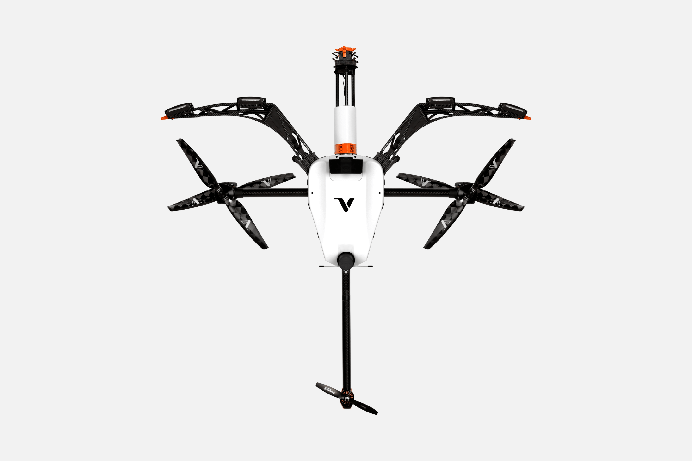
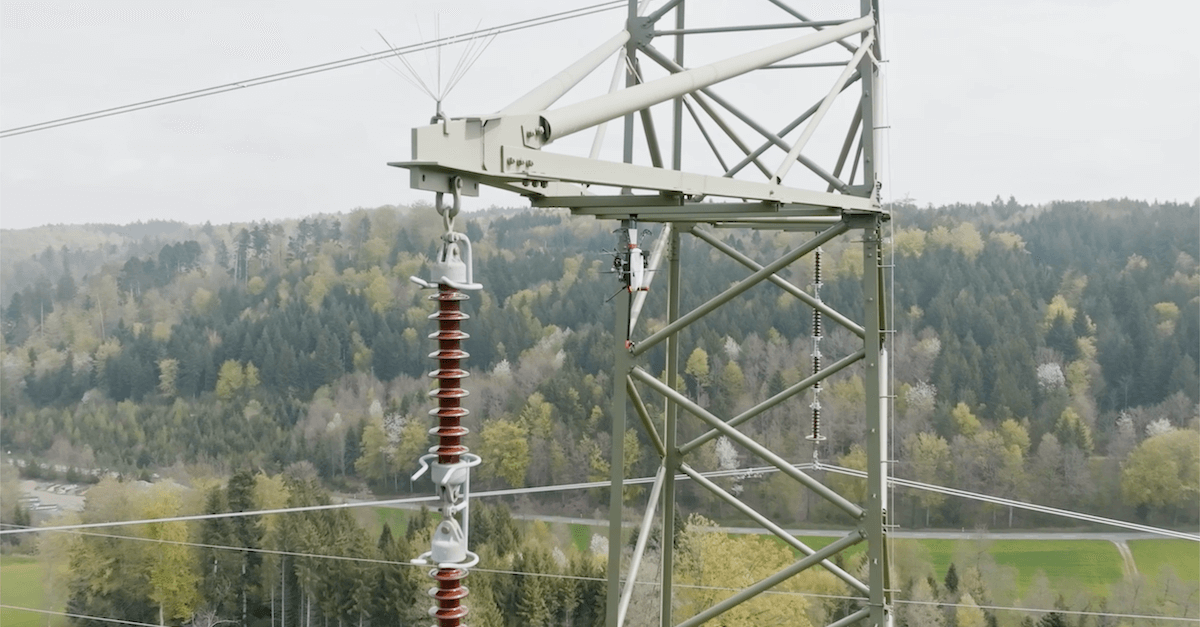
Voliro T is a compact, lightweight tri-copter that performs close-to-structure inspections of hard-to-reach assets. Featuring tiltable rotors, an advanced GPS system, and vision-based velocity sensors, the drone can perform close-to-structure work without any risks of damage.
Voliro can function in GPS-denied environments thanks to an AI-assisted autonomy mode, handy if the signal is patchy due to interference. If there’s a connectivity issue, intelligent auto-descent and position-hold-on modes keep you covered.
With a 4K 12 MP inspector camera with a horizontal FoV 80, you can get a good view of your surroundings. All video is live-transmitted to a companion app. Yet, Voliro’s real edge is non-destructive testing (NDT) of transmission towers and other assets. We offer five interchangeable, ISO- and EN-certified payloads:
Voliro technology collects high-fidelity data without expensive lifting equipment or personnel risk, and at faster speeds. One drone operator inspected protective coating on ten 380 kV transmission towers per day, with no downtime. Voliro offers a subscription, which includes pilot training, first mission support, maintenance, repairs, and certification renewals alongside hardware and software updates.
Main Features
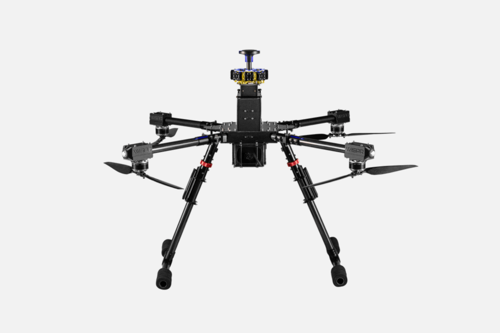
The Ranger Pro quadcopter from Wispr is another popular choice for drone power line inspection. Built with carbon fiber and aluminum, the drone is lightweight (17lb/7.7kg with battery) and durable, resisting winds of up to 50 mph/22.35m/s. The 25000 mAh battery offers 18-45 minutes of flight time, subject to payload weight.
Similar to Voliro T, Ranger Pro is equipped with LiDAR sensors, a computer vision system, IMU, a barometer, and a magnetometer for 360-degree obstacle avoidance even in the dark. For extra positional accuracy, it has an embedded GPS RTK receiver that supports post-processed kinematics (PPK).
Arguably its best feature is EMI-absorbing and EMI-dissipating protection. Connectivity remains strong near high-voltage power lines. If there’s a hitch, Ranger Pro will automatically return to its base. The temperature control system keeps the speed controller and electronics cool, and anti-vibration controls keep the footage crisp.
The downside is that Ranger Pro doesn’t include any payloads out of the box. You’ll need to buy a camera or other sensors separately. Wispr upsells compatible cameras, LiDAR sensors, thermal imagers (specifically, Flir and Workswell Wiris Pro), and ground penetrating radars. The drone’s payload capacity is 7 lb/3.2 kg.
Main Features
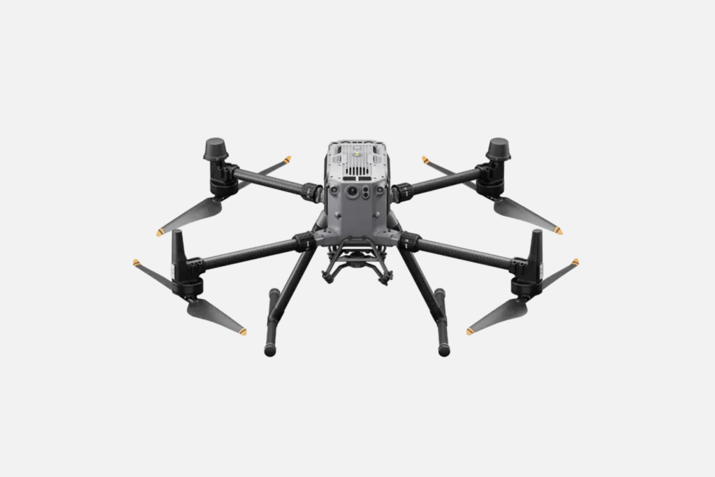
The DJI Matrice 350 RTK is an enterprise-grade UAV that can reach heights of up to 7,000m/22965ft, using high-altitude low-noise propellers. Depending on the external environment, payloads, and flight mode, the drone can hover for up to 55 minutes. The upgraded dual battery system allows hot swapping, extending flight time.
Just like the drone, the new DJI RC Plus controller boasts an IP54 aka it’s dustproof and waterproof. The maximum transmission range is 20 km/12ml. Optional 4G connectivity for BVLOS is available too. Flight modes include sequence pre-planning, route mapping, and oblique route and linear flight missions. New features like high-precision PinPoint and cloud-based real-time mapping allow for complex terrain mapping routes and real-time cloud uploading.
On the navigation side, flight safety is guaranteed by a 6-directional obstacle sensing system and CSM radar, providing 30m/98ft navigation accuracy. A built-in night-vision camera and a mountable infrared sensing system ensure efficient and secure performance at night.
Matrice 350 RTK can carry up to 2.7 kg/5.9 lbs in payload. The native option includes Zenmuse H20 camera sensing systems. For power line inspection, use Zenmuse H20T, which includes a 20 MP zoom camera, 12 MP wide camera, lidar range finder, and 640×512 px radiometric thermal camera. The latter captures R-JPEG images with precise heat signatures of power lines and their potential electrical leakages. You can integrate more payloads using the provided payload SDK.
Main Features
SIRAS is a commercial inspection drone from Teledyne FLIR, primarily for industrial and utility inspections and emergency response. IP54-rated like Matrcie 350RTK, the quadcopter can operate in temperatures from -10 ⁰C to 40 ⁰C / 10 ⁰F to 104 ⁰F and wind up to 10m/s/22mph.
With hot-swappable battery mode, the drone supports up to 31 minutes of flight time. Dual-band 2.4/5.8 GHz control frequency ensures stable connection in high-interference areas. The drone has front-facing obstacle avoidance powered by radars and ground detection sensors.
SIRAS has a quick-connect, swappable gimbal for adding payloads. The two native options are a 16MP earth observation camera and a dual 640×512-pixel radiometric thermal system. The latter lets you measure temperature from the air, picking up excessive heat in your power grid.
SIRAS uses patented MSX (Multi-Spectral Dynamic Imaging) technology to process thermal images in real time, improving clarity, outlining details, and embedding edges. MSX also creates realistic overlays on thermal imagery, preserving labeling, marks, or signatures on assets. Instead of comparing separate images, you can analyze real and thermal graphics together.
Main Features
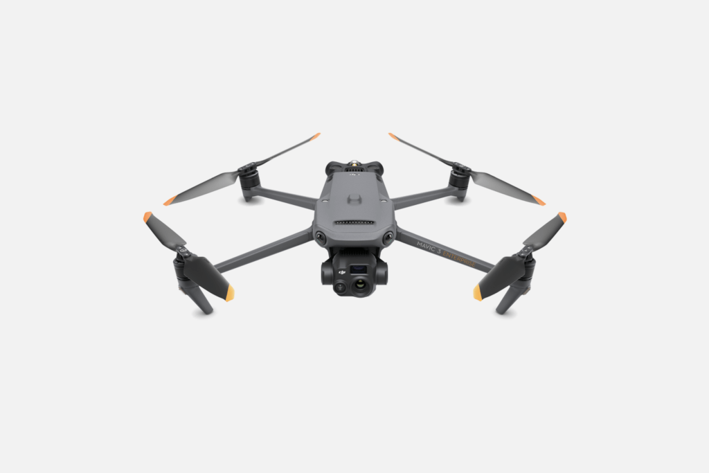
DJI Mavic 3 Thermal is a smaller, more affordable alternative to Matrice 350 RTK. But its battery life and data transmission range are slightly less powerful: 5000 mAh and 8km/5ml respectively. The maximum flight time is 45 minutes, sufficient to cover about 2 sq km/ 500 acres on one charge.
However, its thermal imaging system is as powerful as Matrice 350’s. You get a 4/3 CMOS tele camera, a 56X hybrid zoom camera, and a 640 × 512 px thermal camera. The high-precision thermal camera measures the temperature of large power grids and takes point and area temperature measurements. You receive high-temperature alerts and isotherms in real-time, to the piloting app. Like SIRAS, Mavic 3 Thermal lets you compare regular and thermal images of assets, displayed in double view on the controller screen, but not overlaid.
Because DJI Mavic 3 Thermal is compact (347.5×283×107.7 mm when unfolded without propellers), it has a limited payload capacity of 150 gr / 5.2 oz. The PSDK, however, allows you to add custom sensors and payload controls to expand the drone’s capabilities.
Another great advantage of DJI Mavic 3 Thermal is the GPS RTK system and GNSS support, with vertical and horizontal positioning between ±0.1-0.3m. The RTK also helps automatically plan a power-saving return-to-home flight. Wide-angle lenses on all drone sides offer omnidirectional obstacle avoidance. You can adjust proximity alarms and braking distance to better navigate around complex geometries.
Main Features
IF1200 is a commercial, NDAA-compliant hexacopter designed by Inspired Flight for intensive, long-distance inspections and industrial photogrammetry. The drone can stay in the air for 23-43 minutes and reach a max speed of 56mph/90kmh, depending on payload weight and weather.
Thanks to dual propellers with alternating clockwise and counterclockwise rotation, IF1200 has great hovering stability for close-to-structure work. The drone has 6 flight modes: manual roll-and-pitch maneuvers, high-precision manual movements, pre-planned missions, base auto returns, self-landing, and altitude hold. With SAFE, an embedded safety control, the drone switches to manual flying mode if a motor fails.
Where IF1200 really shines is aerial mapping and industrial photogrammetry. Inspired Flight offers a large selection of optical and multispectral cameras, radiometric thermal devices, EO/IR imaging systems, and LiDAR sensors from top manufacturers. An open interface design also lets you integrate custom options.
A great bonus for electric grid owners: IF1200 is compatible with payload release mechanisms for dropping spare parts and laying power lines. The drone can carry payloads of up to 8.6kg/19.1 lbs. Plus, it can be outfitted with a phase cutter for managing damaged power lines after natural disasters.
Main Features
Power line inspection drones can easily back up your personnel on the most dangerous missions, flying up to high transmission towers, over high-voltage wiring, and across miles of right-of-way.
Equipped with ultrasensitive payloads, drones can locate corroded wiring, insulation cracking, subsurface tower defects, loss of coating thickness, and foundation aging. As first responders, they travel to emergency sites and gather important data on electrical leaks, fallen trees, and fire outbreaks.
But don’t wait for disaster to strike. Perform regular inspections with Voliro T for preventative maintenance. Voliro’s NDT probes help identify problems at the onset at half the time and cost of conventional methods.